Geomorphology
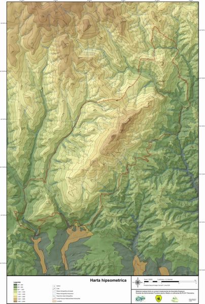
Unlike the Capățănii Mountains of which it is a part, the Buila-Vânturariţa Massif has special characteristics, specific to linear and island calcareous ridges. The main peak has a length of about 14 km, but having a unitary character only between the Costeşti gorges and the Cheile Cheia, with a small interruption in the Curmătura Builei area (here the sedimentary cover has been eroded to the metamorphic deposits here), the rest being fragmented by the To the rivers that dug gorges (from west to east: Bistriţa, Costeşti, Cheia and Olăneşti), which separate two massifs: Arnota (southwest, between the Bistriţa and Costeşti rivers) and Stogu (north-east, between the rivers Cheia and Olăneşti), which have a different appearance from that of the main peak. The ridge has a rugged appearance, only on small areas with smoothed plateaus (Cacova Mountain and Albu Mountain), the dominant feature being that of stepped ridges, dominated by rounded (Piatra, Buila) or pointed peaks (The Wind). The northern sector of the main peak has the appearance of a sharp and jagged ridge, even if the height gradually decreases. Erosion and disaggregation have detached residual erosion witnesses with the shape of towers or needles, some of large sizes (35m), especially on the western slope of the massif. The secondary peaks are generally short (below 1km) and fall in accentuated steps to the east. Only in the Cacova mountain are smooth peaks, and the rounded peak sectors in the Cacova and Piatra mountains. From an altimetric point of view, the maximum elevation is located at 1885 m (Vânturariţa Mare Peak) and the minimum at 550 m (Bistritei exit from Chei). It results in an altitudinal average of 1218 m.
The course of the curves and the distribution of hypsometry within the massif are elongated-concentric. Thus, altitudes over 1800 m occupy two small areas in the central part of the massif, around the peaks of Buila and Vânturariţa, totaling only 1.4% of the surface. Between 1400 and 1800 m is the entire central part of the massif and island, Mount Stogu, totaling 14.5% of the area. The largest expansion is occupied by the interval 1000 – 1400 m, being present both in the Arnota mountain and the Cacova mountain, as well as along the entire eastern border from the central and northern part of the massif. This altitudinal interval amounts to 56.6% of the surface. The part below 1000 m occupies 27.3% and is extended mainly to the south of the Arnota mountain and along the Bistriţa, Costeşti and Cheia valleys.
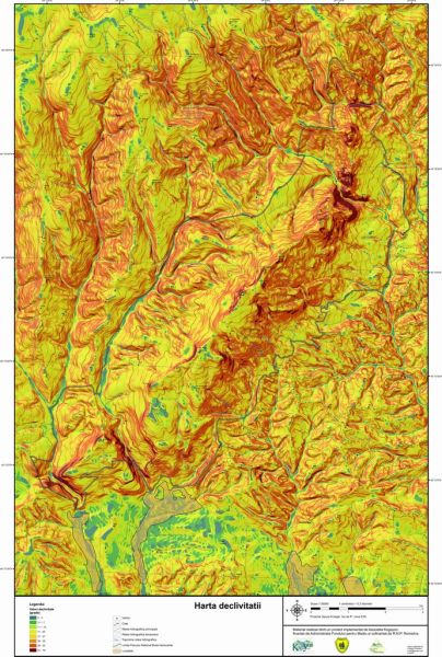
Fragmentation density calculations show that 38.7% of the massif’s surface has values of over 4 km/km2. The highest value reaches 5.2 km/km2 and is located east of Vânturariţa peak. Surfaces with values of 3-4 km/km2 represent 27% of the surface. The average value of the fragmentation density is 3.5 km/km2. Values lower than 2 km/km2 represent 20.8% of the surface of the entire massif. The minimum calculated value is 0.9 km/km2, in the perimeter of the Bistriţa quarry. With the exception of the allochthonous valleys of Bistriţei, Costeştiului, Cheii and Olăneştiului, the valleys with a permanent drainage regime are almost missing. For this reason, the torrential organisms and avalanche corridors that plow the steep slopes have the highest weight in the calculations. The depth of relief fragmentation reaches the maximum value of 820 m. The average energy is 518 m and the minimum around 350 m, generally normal values for mountains with medium altitude. On more than half of the massif area, the relief energy is below 500 m, respectively 24% of the surface below 400 m and 33% between 400 and 500 m. Areas with values of 500 – 600 m represent 15% of the massif. The energy of 600 – 700 m represents 13.5%. The highest values – over 700 m – total 14.5% of the massif’s surface. In many situations, the usual values are high due to the reference of the valleys to the steeps that delimit the main peak of the massif.
The slope of the relief directly influences the type and intensity of the geomorphological processes and strongly leaves its mark on the landscape. The value of the slope is very varied and reaches up to 80 – 900 in the case of steeps, in some places even walls with overhangs appear. The largest extension is the surfaces with inclinations of 40 – 600 (33%), the slopes between 20 – 400 occupy 16% of the surface, the surfaces with slopes of 10 – 200, 10% and below 100, 9%. The same great variety can be seen in the case of the exposure of the slopes. The horizontal and sub-horizontal surfaces represent only 6% of the extent of the massif. The surfaces with eastern and southern exposure occupy 25% and 32% of the surface, respectively, compared to those exposed to the west (18%) and north (19%).
Maps made within the project of the Kogayon Association “Implementation of the Natura 2000 European Ecological Network on the territory of the Buila-Vânturariţa National Park and the realization of the Park Management Plan” financed by the Administration of the Fund for the Environment and co-financed by RNP Romsilva