The Museum of Trovants
How were they formed and what are trovants?
The story of the Trovants
Imagine that more than 100 million years ago, a large part of today’s Oltenia was covered by water. A lot of rivers from the mountains flowed here, bringing with them sediments of various sizes (fine sands, small and larger gravels).

The geological story of the trovants begins more than 7 million ago, when this area looked completely the same as we see it today: in the northwest of this sea, which was gradually filling with sediments, an old river created a delta, on the site where the museum is located today. the trovants from Costesti. What makes these sediments special is that here geologists discovered for the first time these “lumps” of sand and gravel, which they called trovanti.
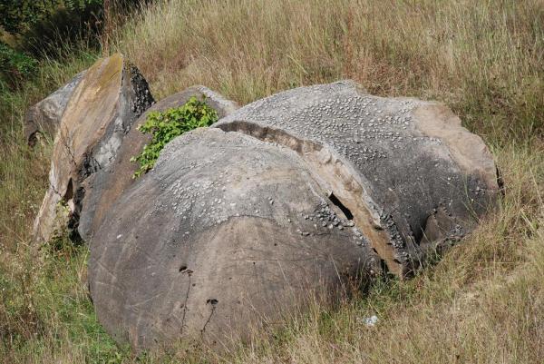
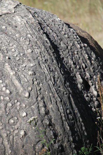
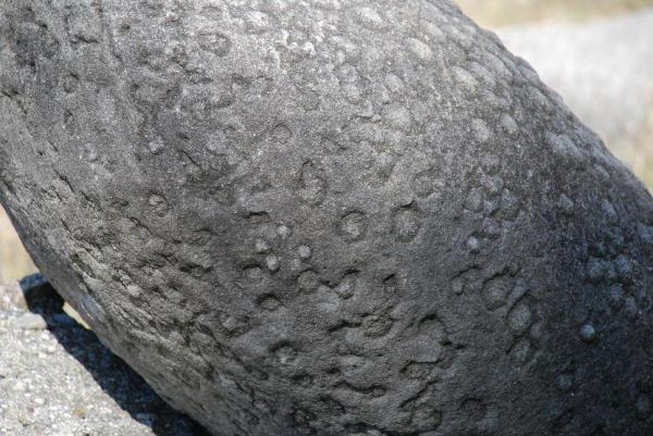
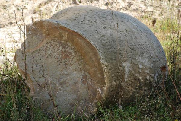
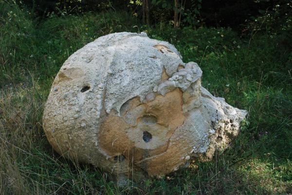
The stones that grow… say the villagers of the places that they are these trovants. And they are partially right. The scientific explanation of geologists is that trovants are formed only under certain conditions: where there are deposits of sand and gravel with high porosity and when water with dissolved mineral substances circulates through the large space between the granules.
These substances, over time, through crystallization, form a kind of cement that connects the granules together around some nuclei and they continue to “grow” acquiring various sizes and shapes.
This process continues even today inside the mountain of sand and gravel from Costeşti.
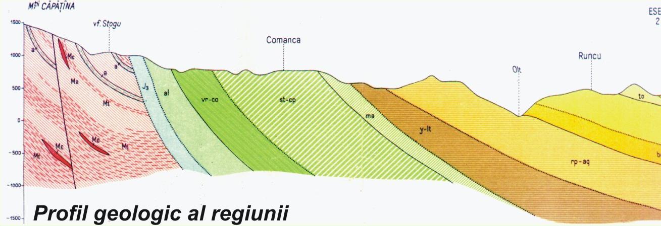
Geology
The trovants are confined in layers of sand of the upper Miocene (inferior Meotian) sand, and the area is part of the geotectonic unit Getic Depression.
The term “trovant” is specific to Romanian geological literature and was introduced by Murgoci (in the work “Tertiarul din Oltenia”, 1907).
The trovants (grassy concretions) represent local cementations in the mass of the sands that contain them and the uneven cementation leads to their different forms, sometimes completely bizarre.
The concretions are agglomerations of mineral substance, with a massive or concentric, zonal structure, formed diagenetically by centrifugal growth. After accumulation, clastic sediments (sandy deposits) change their internal organization thanks to mechanical, biotic and especially chemical causes. In this way, through selective cementation and diffusion structures, trovants (sander concretions) are born. They are characterized by the degree of openness and communication of the interstitial space (porosity and permeability).

The formation process of trovants is considered to be part of the early diagenesis (sydiagenesis). In this stage of sedimentary evolution, transformations take place mainly under the influence of interstitial solutions. Due to the existence of fluids in the interstitial space, the fundamental premise of chemical transformations, the cementing process appears.
To explain the appearance of cement from porous space, cement that acts as a binder of pre-existing clasts, it is taken into account that:
- The direction, speed and mode of movement of fluids were controlled by pressure gradients and density differences;
- The cement was deposited in the compression sediment from solutions, the chemistry of which resulted from the local interaction between the interstitial fluid and the pre-existing clasts;
- The factors that control the formation of cement are: concentration of solutions, pH, EH, system temperature, geostatic and hydrostatic pressure.
So: the composition of the concretions indicates the composition of the dispersed mineral phase and the conditions of the genetic environment (pH, EH, the presence of the organic substance), and the structure and texture of the concretions (massive or concentric, micro- or macrocrystalline) will reflect the precipitation conditions in the space sediment (porosity, permeability, hydrostatic pressure, temperature).
The two essential conditions for the formation of trovants would therefore be the following:
- the existence of sandy sediments and the preservation of a wide porosity despite the normal compaction caused by pressure;
- The presence of local concentrations (with non-uniform distribution) – “segregations” – of specific minerals with secondary components dispersed in the host rock (carbonate fluids in the sands).
Legends and stories
There are many legends
…and some speak of some strange stones that, in the evening, hidden from the curious eyes of people, speak, whisper, move… There are rumors that they are the eggs of extinct creatures, like dinosaurs, or that humans themselves have sculpted. It is said that they would be charged with positive energy or that they would grow every time after the rain.
These forms, often bizarre, take on the most different appearances: from dragons coiled in a deep sleep, to wavy backs lazing in the sun, turtle shells and horned ram’s heads ringed. Often you have the impression that you are in a sculpture camp, but you are in the workshop of the most skilled craftsman of all: nature. The workshop awaits those who step with imagination to discover the hidden riddles of other trovants!
To explain the appearance of cement from porous space, cement that acts as a binder of pre-existing clasts, it is taken into account that:
- The direction, speed and mode of movement of fluids were controlled by pressure gradients and density differences;
- The cement was deposited in the compression sediment from solutions, the chemistry of which resulted from the local interaction between the interstitial fluid and the pre-existing clasts;
- The factors that control the formation of cement are: concentration of solutions, pH, EH, system temperature, geostatic and hydrostatic pressure.
So: the composition of the concretions indicates the composition of the dispersed mineral phase and the conditions of the genetic environment (pH, EH, the presence of the organic substance), and the structure and texture of the concretions (massive or concentric, micro- or macrocrystalline) will reflect the precipitation conditions in the space sediment (porosity, permeability, hydrostatic pressure, temperature).
The two essential conditions for the formation of trovants would therefore be the following:
- the existence of sandy sediments and the preservation of a wide porosity despite the normal compaction caused by pressure;
- The presence of local concentrations (with non-uniform distribution) – “segregations” – of specific minerals with secondary components dispersed in the host rock (carbonate fluids in the sands).
About the reservation
The Nature Reserve Museum of Trovanilor Costesti has been managed since 2006 by Kogayon Association, non-governmental organization based in Costeşti, based on a custody agreement signed with the Vâlcea Environmental Protection Agency.
The reservation was established by Government Decision no. 1581/2005 regarding the establishment of the protected natural area regime for new areas (heading B.3.).
According to the legal provisions and obligations of the custody agreement, Kogayon Association drew up a Regulations, a Management plan and a Action plan of the reservation, documents sent for approval to the Ministry of Environment and Forests, in which the activities carried out in its perimeter are regulated.
The main purpose of the reservation with an area of 1.1 ha is to protect the geological formations called Trovanti and is located on the territory of the Costeşti commune, Vâlcea county and was established based on the opinion of the Romanian Academy – the Commission for the Protection of Natural Monuments.
The Museum of Trovantilor was established as such in 1996 by a team from the Faculty of Geology and Geophysics Bucharest – Society for the Protection of the Geological Environment, as part of a project for the development of the area as an open-air geological museum. Within this project, the geological formations (trovants) were arranged in the area at the base of the sand quarry and information panels were installed in the perimeter and indicators on the road. From that moment, no arrangements were made in the area, over time the panels deteriorating or disappearing, some of the geological formations were taken from the perimeter, others had their location changed. In the meantime, the exploitation of the sand in the quarry continued, thereby bringing to the surface other geological formations.
The relief of the area was shaped anthropically by opening the sand quarry on the hillside, without which even the trovants would not have been brought to light from the sand layers. The main geomorphological element is the 30 m high cliff of the sand quarry, located in the eastern part of the reserve. Another cliff, smaller (5 m high), is located in the north of the reserve, towards the road. At the base of them, below the level of the road, the land is relatively flat, with small bumps (mounds of sand over which the vegetation has grown. In the south of the reserve there is a valley: Valea Nisului.
Since 2006 in the reservation Kogayon Association He carried out several activities for the administration of the reserve, aimed in particular at the arrangement, information and awareness of locals and visitors, promotion, ecological education and maintenance.
The arrangements made were: the placement of a bilingual information board, the management of a stopping place with a table, benches and garbage container, the marking of the limits of the reserve, the security of access with a barrier.
Costeşti City Hall has set up a parking lot opposite the reserve, on the land where it is to be built and arranged in partnership (Buila-Vânturariţa National Park Administration, Costesti Town Hall and Kogayon Association) A tourist visitor center of the park, the reserve and the area.
Reserve limits:
– The northern limit molds the curved route of D.N. 67 (r. Vâlcea – Costeşti – Horezu – Tg. Jiu – Drobeta Tr. Severin), between km 35 + 700 m – km 35 + 800 m;
– The eastern limit starts from D.N. 67, km 35 + 700 m, follows the upper part of the outcrop (quarry) of sand, along the edge of the beech forest (private property), up to the Valea Nisului stream;
– the southern limit is represented by the winding course of the Valea Nisipului stream, on a length of 140 m; The limit starts in the eastern part of the perimeter, from the point where the upper edge of the quarry/sand outcrop descends in the valley line and then continues down the stream downstream, up to the wire fence (which constitutes the western limit of the protected area);
– The western limit starts from D.N. 67, next to km 35 + 800 m and follows the fence (wire) that separates the protected area from the neighboring private property, up to the Valea Nisului stream.
Surface description:
The reserve includes a non-productive, uneven land and a sand quarry (outflower) with western exposure, being located in the outskirts of Costeşti, at the base of the Costeşti (Zlamene) hill, adjacent to D.N. 67. The reservation is part of body B, the plot registered in the land register no. 148 of the Costeşti commune, having no. cadastral building 313. The topographic plot is raised to a scale of 1:1,000 in 2005 and has a total area (including quarry) of 1.1 ha.