Traseu 2 - Horezu – Olănești
Horezu – Romanii de Jos – Dealul Neagota – Bistrița – Bistrița Monastery – Culmea Stogu – Pietreni Village – Costești Hill – Bărbătești Village – Dobriceni Hill – Dobriceni Village – Delușelu Hill – Village Popești – Neghinești Village – Debrădet Stream – Păușești-Măglași – Olănești Valley – Vlădești – Rm. Vâlcea – Ocnele Mari – Ocnița – Teiușu Village – Gătejești – Govora Sat – Baile Govora – Pietrari – Bârzești – Negrălești – Costești – Bogdănești – Horezu
Descriere:
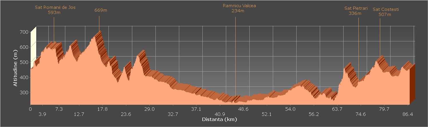
The route is mostly asphalted, having 5 unpaved sections, each of 3.1 km, 2.4 km, 2 km, 0.5 km and 4.3 km, totaling 12.3 km unpaved, i.e. 14% From the total of 86.4 km. Unpaved portions are cobbled and in good condition.
There is no difficulty in orientation and finding stopping places and for refueling, the route passing through numerous localities.
The route starts from Horezu, the starting point being the Tourist Information Center, located in the center of the city, near the C-tin Brâncoveanu High School. Here you can get more information about the tourist area of Oltenia below the mountain and about the Buila-Vânturarița National Park. Also here you can find maps of the cycling and mountain bike and trekking routes in the area.
The route is almost 87 km long but can also be covered partially, on several smaller loops with a starting point from Horezu or any other locality (Romani, Costești, Bărbătești, Stoenești, Păușești, etc.), with lengths between 15 and 87 km, using for Round and rounded the same parallel axes and shortening the route using paved connecting roads:
Romans – Hill of Ulm – DN 67
Bistrita – Costești – DN 67
Pietreni – Costești – DN 67
Bărbăți – Bodești – Barzești – DN 67
Deleni – Gruiu – Stoenești – DN 67
From the Tourist Information Center, start towards Rm. Vâlcea (east) so that after only 100 m you turn left at the first intersection. After another 50 m, turn right to the east, cross the bridge over the Urșani river and after another 500 m, reach the intersection with the road to the village of Râmești. Here you turn left towards Râmești, so that only after 10 m turn right and resume the direction to the east. Climb 500 m to Ulmului Hill (view of the Buila-Vânturarița National Park, the Căpățănii Mountains and the Hurez Monastery), then go down 400 m to the intersection with the road that goes to the Romans. Turn left towards the Romans and after a section of 1 km of flat, you reach a new intersection, from where our route goes to the Hurez Monastery (before the road continues towards the Romanii de Sus). After 300 m we reach an intersection next to a spring before the guesthouse at the gate of the Hurez Monastery. You can visit the monastery immediately to the north and the other sights around it.
Our route continues on the secondary road on the right (southeast), ascending through the village. The climb has 1.7 km, of which only the first 0.9 are asphalted. At the top of the slope, the village also ends, after which there is a short descent of 300 m into the forest to the Neagoții Valley, then it continues 1 km to the east through orchards and hayfields from the edge of the forest (flat and short ascent at the end). From the top of the slope we descend briefly on the edge to the south (200 m), then we resume the eastern direction in the descent 0.8 km until we meet the asphalt again (after the first unpaved section of 3.1 km) in the road that goes to Bistrița.
We turn left towards Bistrița and after 2.4 km through which we go up and down the hill next to the Stogu island we reach the gate of the Bistița Monastery. Here we can visit the monastery and the surrounding sights, the Bat Cave, the Bistriței Chies, the Păpușa Hermitage, the Secular Chestnuts. From the gate of the monastery, it continues to the north, after 200 m we cross the bridge to the east over the Bistrița river and start the second unpaved section, 2.4 km away, on the road that goes up to the Arnota Monastery and the limestone quarry. We start with a demanding climb of 1 km, to a ridge from where we leave the road to the quarry (you can continue PWE 3 km uphill to the Arnota Monastery). We fall on a road to the right, which passes over the conveyor belt, then we go down 1.4 km to the southeast through orchards and hayfields to the village of Pietreni. Here we meet the asphalt again, we start to the north (left) in a slight climb 1.5 km to an interest at the entrance to the Buila-Vânturarița National Park marked with information boards, tourist and road signs (Bărbătești).
We go to the right (east) towards Bărbăți, starting a 1.8 km climb (only the first 0.6 km paved), in the summit we have a section of 0.5 km of flat, but also an extraordinary road to the Buila-Vânturarița National Park. The descent starts with a section of only 300 m unpaved and continues with another 2.1 km paved, with sections with a slope greater than 10% to the village of Bărbătești. The third unpaved section accumulates 2 km, more the climb from Pietreni. At the intersection with the road from the Otăsăului Valley, we turn right to the south, after 200 m we pass an intersection where we keep right and after 1 km in a slight descent we reach the center of Bărbătești. From here we go to the left (east) in a sharp ascent (10%) of 0.6 km. The portion at the top (view to the Buila-Vânturarița National Park) and the beginning of the descent represents the 4th unpaved section, only 0.5 km away. The descent to Stoenești has a total of 2.4 km. After the school, the bridge is crossed and a new climb of 1.3 km begins (slope 10%). After a descent of 0.9 km and 100 m flat, you reach an intersection (Stoenești – right, Paușești – left). We go to the left towards Păușești, enter the village of Deleni, climb 0.8 km in the village of Piscul Mare and another 1.4 km to the village of Neghinești (only the first 0.6 km being asphalted). The last and longest unpaved section of the route (4.3 km) continues downhill. At 150 m we meet the intersection with the road that goes to the Jgheaburi Hermitage (3 km left to the north), after another 1.9 km we reach the intersection with the paved road towards the village of Zmeuret (3 km right to the south). There is a slight descent of 1.6 km, after which we meet again the asphalt, which we arrive after 2.4 km in Păușești-Măglași, at the intersection with the road Rm. Vâlcea – Băile Olănești.
From here we have 6.7 km to Rm. Vâlcea. In order to avoid as much as possible the congestion and heavy traffic on the main roads, we found some detours to avoid when returning from Rm. Vâlcea the national roads and which also offer us the possibility of visiting some interesting places and objectives.
for to avoid crossing the city of Rm. Vâlcea through the center there is this option that from the church located 100 m after the entrance sign to the locality, we go to the right on Albinei street, after 300 m we cross the bridge over the Olănești river, after another 200 We turn to the left and after 3.4 km we reach Traian Calea lui Trajan on the streets of Arinilor and Morilor. We then turn right on the main street of Râmnicului, after 2.2 km we turn right towards Horezu – Tg. Jiu and continue 4.4 km to the intersection with Ocnele Mari. From here we go to the right to Ocnele Mari, pass the intersection with the road to the salt pan (right, you can visit), the center of the town, the salt water retention basin (right) and after 4.5 km we reach the intersection from the right The Salin beach in Ocnița, from where we go to the left towards Bunești. There is a 2.1 km ascent, a 4 km descent interrupted by a short ascent but also by a viewpoint towards the Buila-Vânturarița National Park and a 0.9 km palt section until we meet the national road again. From the intersection we turn 1.6 km towards Rm. Vâlcea (left), to the intersection with the road to Băile Govora. From here we can also visit the Govora Monastery, located 3 km to the south. We turn right towards Băile Govora, to where we have 3.8 km (the entrance to the park, after crossing the center of the resort). From the entrance to the park, we climb to the left 1.9 km (demanding climb, with serpentines), to the intersection with the road to Paușești-Otăsău (left) we are going. We go up another 0.7 km to the top of the hill, then we descend sharply 2.2 km to the U Interejection from where we can go south to Francești to visit the Wooden Monastery (6 km). We go to the right (north) 1 km until we meet again in Pietrari the national road on which we will go on the left 14.5 km to Horezu: 3.5 km flat to Bârzești (intersection towards Bărbătești), another 2 km flat to the Negrălești, ascent 2.2 km to Costești Hill, descent 0.5 km to the Costești Trovantilor Nature Reserve and another 1 km to the intersection with the road to Costești, 1 km flat to the intersection with the road to Tomșani, 2.3 km Easy climb to Ulmului Hill, easy descent 1.3 km between workshops and ceramic shops to the intersection with the road to Măldărești and another 0.7 km until we reach the starting point, at the Tourist Information Center Horezu.